| Legole.Com Discover china. Explore the beauty and wonder of the land, people, and culture of China. |
 |
| Mt. Yushan (Jade Mountain) |
 Mt.Yushan is situated in the Yushan National Park with an elevation of 3952 meters. It has 11 peaks, of which the highest are the Main Peak and the North Peak. The North Peak is the site of the highest building in Taiwan, the Central Weather Station. Mt.Yushan is situated in the Yushan National Park with an elevation of 3952 meters. It has 11 peaks, of which the highest are the Main Peak and the North Peak. The North Peak is the site of the highest building in Taiwan, the Central Weather Station.
Mt. Yushan is steep and rocky. Rockfalls and crumbling cliff faces can be seen in a lot of places. With its precipitous peaks, it is the must-conquered place for the mountain climbers. The rainy season last from May to August with an annual rainfall of 3,000 to 4,700 mm. Therefore, the best time to climb the mountain is from October to December during the dry season. From January to March, deep snows at the upper reaches of the mountain make climbing without experience and proper equipment difficult and dangerous at times.
The mountain's very height results in a range of climate from subtropical at the lowest levels through a warm and humid belt and then a cold and damp belt, and finally a cold high altitude.
Due to the various climates in the mountain, many species of mammal, such as black bear, wild boar, water deer, longhaired mountain goat, flying squirrel, monkey, and rare plants of different climatic zones live there. About 151 species of birds and 228 types of butterflies, as well as several kinds of snakes, can also be seen on the mountain.
As you begin to climb the mountain, the Tatachia Visitors' Center is the entrance to the Yushan trail. From north to south, there is a long narrow meadow and crest line. To the east is Yushan and to the west is the Alishan Mountain Range and watershed.
The walk from Tatachia to Paiyun Hostel takes about five hours and is arduous, but not dangerous. On the way here, visitors will pass through the "white forest," a grove of trees weathered white. With about 100 beds, the hostel becomes much crowed during the peak tour period.
In order to see sunrise, climbers generally get up at about 3 a.m. and, with flashlights, start the final climb to the summit. The slopes become much steeper than those on the walk up from Tatachia, and this climb will take 2 hours. Because winds are particularly strong at a certain spot near the peak (it is aptly named" Wind Mouth"), a chain fence was built to protect climbers.
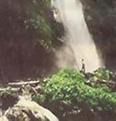
After viewing the magnificent sunrise, some people retrace the route down to Paiyun Hostel and Tatachia, while some continue down the other side of the mountain to the hot-spring town of Tungpu. This route involves a walk of about 1 hour along the Patung-kuan Trail which was built in 1875 during the Qing Dynasty. Leaving the peak, climbers follow a branch of the Patung-kuan Trail that leads 6.5km down the east face of the mountain to where it joins the main trail. On the trail leading all the way down to Tungpu, climbers will discover many spectacular scenes including several waterfalls, one of which cascades down the mountain in seven steps and is known as Seven Threads Waterfall.
Under to Tungpu is Dragon Cloud Waterfall, which drops 50 meters over a stone cliff, runs under a wooden bridge, and then drops another 70 meters.
The final stop of the trail is carved into the vertical face of Father and Son Precipice', after which the trail crosses the Chenyulan River and leads into the town of Tungpu.
Tel: (049)773-121-258 |
|
|
|
|
|