| Legole.Com Discover china. Explore the beauty and wonder of the land, people, and culture of China. |
 |
|
|
|
 Location: situated in the southwest frontier of China; south foot of the Mt. Tianshan, the hinterland of Xinjiang Uygur Autonomous Region; the edge of Takelamagan Desert; the northeast edge of the largest basin in China, Tarim Basin Location: situated in the southwest frontier of China; south foot of the Mt. Tianshan, the hinterland of Xinjiang Uygur Autonomous Region; the edge of Takelamagan Desert; the northeast edge of the largest basin in China, Tarim Basin
Neighboring areas: Gansu and Qinghai Provinces, Tibet Autonomous Region
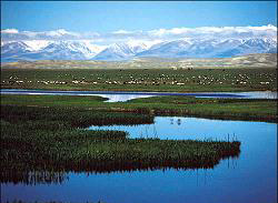
Physical Features: higher north and lower south terrain, forming sloping oasis like a fan; Kongquehe River flows its way through its whole area; the branch of Tarim River flows through the south of the urban
Population: 330,000
Urban Population: 20,0000
Area: 7116.9 sq km
Nationalities: Mongolian, Uygur, Han, Hazake, Hui, Kerkezi, Xibo, Tajike, Wuzibieke, Tataer, Dawoer, Manchu and Russian
History: with thousands years history, Korla is a throat in the middle of the Silk Road in history; it was set up as a county early in 1940, a prefecture in 1954, merged into the Bayin'guoleng Mongolia Autonomous prefecture in 1960, being approved to be as a city on October 1979
Climatic Features: dominated by continental climate, the area is dry with light rainfall, a high evaporation rate, lots of sun and a huge temperature disparity between day and night
Average Temperature: 7-14C annually with great daily temperature difference
Rainfall: annual precipitation 25-100 mm
Mountains: the Tianshan Mountain Chain; Mt. Aerjinshan
Rivers: the Bosten Lake, Kongquehe River, Tarim River, Kuerchu Brook, the Yinyanghu Lake, and the Lianhuahu Lake
Local Highlights: Korla sweet pear; tomato; muskmelon; little apricot in white; fig; mulberry |
|
|
|
|
|